Heidelberg old town topographical map created with MapLab3D
by AndreasKilthau · via Thingiverse
| Format | STL |
| Category | Art |
| License | CC BY |
| Uploaded | Mar 15, 2026 |
⬇ 129 downloads
👁 41 views
Description
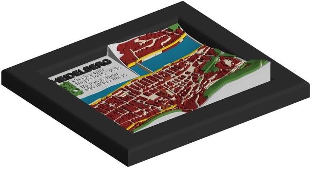
This model was created using the MapLab3D app. MapLab3D is a tool for creating 3D models of maps in STL format from freely available OpenStreetMap data and elevation data which can be printed on 3D printers without further processing. No other CAD tool is required. Instructions for creating this map can be found here . The purpose of this map is to provide a quick start in as few steps as possible to the most important functions of MapLab3D by following the step-by-step instructions. Further information about MapLab3D can be found on GitHub and in the MapLab3D Wiki . If you want to make your own changes to the standard map layout, take a look at this example with detailed instructions . This map consists of 10 different colors and 53 individual pieces. The following colors were used: C001: Tile base: Fillamentum PLA Extrafill Electric Grey C002: Legend: Fillamentum PLA Extrafill Traffic White C006, C009: Forests: Fillamentum PLA Extrafill Green Grass C007: Settlement areas: Fillamentum PLA Extrafill Perl Ruby Red C013: Historic/religious areas: Bambu Lab PLA Basic Brown C016: Water: Maertz PLA Himmelblau C018: Highways: tertiary, minor: Fillamentum PLA Extrafill Light Ivory C019: Highways: secondary: Fillamentum PLA Extrafill Traffic Yellow C020: Highways: primary: Fillamentum PLA Extrafill Melon Yellow C028: Texts: Fillamentum PLA Extrafill Traffic Black
Originally published on Thingiverse